Sussex County, Delaware History

The territory occupied by the present
county of Sussex was known in the seventeenth century as
Hoorenkill, Horekill and Whorekill, and extended from Bompties
(Bombay) Hook to Cape Henlopen (Fenwick Island). The first
settlement was on the site of the present town of Lewes.
In 1658 Lieutenant Alexander De
Hinijossa was given command of the Horekill, and was succeeded
by Peter Alrichs,1 nephew of
Vice-Director Jacob Alrichs, as commandant, in 1660. The
territory was controlled by the Dutch authorities at New Amstel
(New Castle), and Peter Alrichs, by reason of his official
position, obtained a monopoly of the trade from Bompties Hook to
Cape Henlopen, causing considerable dissatisfaction among the
inhabitants, who complained to the Vice-Director William
Beekman, of Fort Altena, and he wrote to Director Stuyvesant Two
years later, 1664, the territory passed into the possession of
the English.
On April 22, 1665, Captain Martin
Creiger, was granted permission to trade in Delaware Bay, and on
November 11, 1665, Peter Alrichs was allowed to traffic at
Horekill for "skins, peltry or what other commodities those
parts would afford, he to make entry with the officers at
Delaware (New Castle) of the quantity and quality of goods."
On March 20, 1666, all duties on
household goods were discontinued on the Delaware River, and on
October 22, 1670, on petition of the inhabitants, all customs
were abolished.2
On January 12, 1670, a grant was made to
James Mills for a "neck of land" lying "to the southward of the
town called Whorekill" He was also given the privilege of buying
the Indian right. The survey accompanying the grant was as
follows:
Fac-Simile
of Survey of the Coast Along the Delaware Bay3 and
the Sea, Made January 12, 1670.
Explanation
1. Love's Creek. 3. Herring Creek. 3.
Big Ditch. 4. Indian River Bay. 6. Rehoboth Bay. 6. Islands. 7.
Cape Henlopen (the present). 8. Trading Poet, and site of the
present town of Lewis. 9. Cape Henlopen, the present Fenwick
Island.
On May 8, 1671, the following census of
Horekill was taken:
"Hilmonus Fredericks Wiltbank, his wife two sous and a
man servant. 5
Alexander Moelsteen, his
wife, two sons and a man servant 6
Otto Wolgart, his wife, one
son and a man servant 4
William Klarsen, with two
daughters and a child 4
Jan Kipehaven, his wife and
daughter 8
James Weedon, one daughter,
one son and four servants 8
John Bods (Roades) his wife,
five children, three sons and two daughters 7
Daniel Breen, his wife and
partner, John Colleson 3
Jan Michael, Anthony Pieters,
Abraham Peters, Peter Smith 4
Pieter Gronedick, Anthony
Sandes 2
Herman Cornelissen, Herman
Drooche, trader 2
Total 47
There are here at present on
Captain Martyn Cregiers' sloop Belfast, 6
Also on a small boat of Peter
Aldrich, from New Castle 2
Hermanus F. Wiltbank. |
On June 14,
1671, the Council adopted an order in reference to land taken at
Horekill to the effect that "what is past or granted there be
confirmed upon the same conditions as the rest of ye Land, with
this Proviso, that each Planter be obliged to settle upon the
Land, & that each Person be enjoyned to settle a House in a
Towne to be appointed near them."
At this time
little land had been taken by the settlers, excepting in and
near the town of Horekill; but the residents of Maryland showed
a disposition to locate them. The southern and western
boundaries were in dispute, and as Lord Baltimore and Governor
Lovelace were uncertain as to the exact location of the line,
considerable difficulty and uneasiness resulted. In June, 1672,
Richard Perrot, of Virginia,"4 wrote
to Governor Lovelace concerning this question;"5
"May
it please your Honor:
In May last myself, with some
other Gentlemen of Vergeney, came over to Delieware to
see the place and liking the place we made choise of
several tracts of Land for ourselves and nabors and had
made bold to have given your Honor a visit had not one
of our company fallen ill so that we implied Mr. Waiter
Wharton for to paten our Land. Now May it please your
Honor about four days before I came to see the Maryland
men have survaed it again in the Lordes name. I much
fear it will disharten the rest of the gentlemen from
coming up at the falle and several more of our nabors
that would have come up at the fale of the lefe very
Honest men and good House-keepers, they desired me to
take them up sums land, which I am doubtul to done
unless your Honor will be pleased to give me permission
for it. I dout not but to see the place well seated in
tow or three years at the and a trade from Louden; the
place is good and healthy and wanteth nothing but
people. I was in good hopes I should have had the
happiness to have got up before your Honor left
Delieware, but my hopes was in vain. I hope your honor
will be pleased to honor me with a line or two whoe is
your faithfully and obedient servant unknown.
"From the Horekill, "Richard
Perrot."
"June 21, 1672.
"If your Honor please to
grant us all the land to us Virgenianes that lieth
between the Horekill and the Mortherkill we shall take
spedey care for the seating of it, as may be expected at
so great a distance when Layed out according to menes
families; what good land there may be found in the
distance I know not; at present we have a desire to be
near together as the please will afford. I intend
Vergeney for sum occasions of business and send up my
son.
"R.P." |
In July,
1673, when the Dutch again came into possession of the
territory, Peter Alrichs was reap-pointed commandant at
Horekill, from Bompties Hook to Cape Henlopen, and among other
instructions was "authorized, for the promotion of Agriculture,
to assign lauds to the inhabitants of South River," subject to
the approval of Governor Anthony Colve, and to call for
confirmation and proper title-deeds after the lands had been
surveyed by the sworn surveyor.
After the
re-occupation by the English, in August, 1674, Captain Cantwell
wrote to the Governor, informing him of affairs in the Horekill,
to which the Governor replied that he was "glad to hear that
people are generally so well satisfied with the change, and of
the likelihood you tell me of newcomers to settle in those
parts. In the mean time you may give to such newcomers as desire
to continue there any reasonable quantity of lands not disposed
of or settled in time, according to their capacity and number of
hands they shall bring for clearing it; and, till my arrival or
order, do further empower you to be surveyor for the whole river
and bay."6
On July 7,
1665, eighty acres of land were granted to Alexander Molestidy (Molestine),
"lying upon the Whorekill, near unto the mouth of the kill,"
adjoining the land of William Tom, and one hundred and
thirty-two acres were granted to Hermanus Wiltbank on the
Whorekill and Pagan's Creek, also adjoining the land of William
Tom.
On March 26,
1676, patents were granted as follows:
Henry
Stricker (Stretcher), 600 acres
Timothy Love (Rehoboth Creek), 411
acres
John King, 900 acres
Randell Revell, 900 acres7
Robert Windsor, 1100 acres
Daniel Hart, 500 acres
John Roads, 850 acres
Daniel Brown, 400 acres
Alexander Molesteen, 411 acres
Abraham Clenning and Otto Wolgast,
600 acre
Hermanus Wiltbank, 800 acres.
On June 15,
1676, Edward Codell was granted three hundred acres, called
"Edward's Choyce," "lien in the woods south-southeast from the
Horekill town, distance three miles, near unto Green branch."
On June 11,
1677, Hermanus Wiltbank wrote to Governor Andross from Horekill:
"Right Honorable:
"Whereas I am Informed, very
creditable, that those of Maryland have surveyed some
inconsiderable quantity of Land, the certain quantity
unknown, but is supposed to be several thousand acre,
the which Land Lying within the Limits of this
government, As I can produce by an Instrument In
writing, made between the Christians and the Indiana, In
the first settlement of these places being bought and
paid for, as the Writing more at large may manifest,
being to the southward of Whorekill Creek about the
distance of 18 or 20 miles, But to the northward of the
supposed Cape Henlopen and the extended limits according
to the aforesaid Writing being called Assawoman Inlet,
conveniently at the seaboard side, wherefore I have
already acquainted several persons that what
encouragement, privileges and Assistance can or may be
procured from your Honor shall not be wanting if that
any persons are willing to settle there. In those parts
aforesaid under the protection of his Royall Highness." |
In 1677 the
appended 1 st of settlers in the Horekill were given as
belonging ''to the company in Delaware," and in 1678, Captain
Edmund Cantwell, of New Castle, obtained land patents for them:
John Alward
John Autry 300 Acres
William Borton 1000 Acres
Richard Brasey 300 Acres
Robert Brasey, St. 800 Acres
Robert Brasey, Jr. 300 Acres
Thomas Davis 300 Acres
Thomas Davis 500 Acres
John Dupre 1000 Acres
Abraham Clement 400 Acres
John Comlia
Edward Cooper 360 Acres
Josias Coudrey
Robert Frazer 400 Acres
Edward Furlong 400 Acres
Robert Hart, Jr 600 Acres
Richard Hill 1000 Acres
Christop Jackson 300 Acres |
John Johnson 400 Acres
John Kirke 800 Acres
Walter Lewis 300 Acres
James Lille 300 Acres
John Linning
John Olton 300 Acres
James Pedy 600 Acres
William Prentice
Sander Moleeteyn8 50 Acres
Henry Stretcher 400 Acres
Jacob Seth 500 Acres
Samuel Styles 400 Acres
Sam'l Styles & Trayly 744
Acres
William True 300 Acres
Cornelis Verhoofe
William Warren 300 Acres
James Wells 400 Acres
Daniel Whitley |
Tracts of
land in Horekill were taken up as follows:
In 1677, by
Otto Wolgast, one of the magistrates, a tract of two hundred and
forty acres, called the "Vineyard," "near unto Rehoboth."
On December
8, 1677, by James Laten, "Hart's Delight," four hundred acres
"lien and bein in Cedar Creek."
On January
15, 1677, by Cornelius Johnson, "Johnson's Delight," six hundred
and twenty-two acres, formerly surveyed for Hermanus Wiltbank,
lying on the north side of Kimball's Creek.
On January
16, 1677, four hundred acres to Henry Hermon, called "Hermon's
Choyce," near a marsh called "Kimball's Neck."
On November
13, 1679, Captain Edmund Cantwell certified to the following
grants, "the names starred being already seated and the others
intended to seat next winter":
Captain John
Avery, 800
Richard Beaty, 421
John Cooley,* 600
John Crows,* 900
Andrie Dupre, 400
Anthony Enloss,* 150
Thomas Goward,* 600
Henry Harmon,* 400
Robert Highnet,* 622 |
Cornells Johnson,
600
James Liten,* 400
Paul Marsh,* 600
Francis Meggs.* 600
John Oakey, 400
Simon Plaing,* 300
Cornelis Verhoofe, 1210
Jessey Sumerford, 800 |
Alexander Molestine and John Briggs, 800
Hendrick Molestine, John Kiphaven, Jr., Cornelis
Verhoofe and Hermon Cornells,* 800 |
On May 14,
1679, William Clarke, one of the justices of the court at
Horekill, wrote to Governor Andross:
Governor Andros:
"Since thee were pleased,
when I was at Yorke, to Ask me if there was anything
knew relating to this place for thee to settle or order
doth Imbolden me to Lay one thing before thee, which I
observe to be a grievance and that which does prevent
the better seating of this country, and that is, they
that have land here are not at any certainty what they
must do for the surveying it. The planters that come out
of Maryland are and have been in expectance that they
should pay no more than is paid for surveying these,
which is one hundred pounds of Tobacco for the first
hundred acres, and fifty pounds for the second hundred
acres, and twenty-fire pounds for every hundred acres
after to one thousand acres, so that the surveying of
one thousand acres of Land come to but three hundred and
fifty pounds. But instead thereof same have paid here
two thousand pounds of tobacco for surveying one
thousand acres, and none that I hear of have paid Lease
than one thousand pounds for surveying one thousand
acres of Land, which may be done in a day's work or less
and is looked upon as a great Burthen complained in by
the planters. And they do say it doth hinder others from
coming to seat in this County that had thought of
coming. This I thought fitt to signify unto thee; being
always willing to Appear in that which may be for the
prosperity and well-being of that place which I eat my
bread in; And leave it to thy consideration to return
such answer and directions, hereunto, as in thy great
wisdom shall seem discreet; And as this finds acceptance
with thee, I shall the more freedom hereafter as things
presents; And subscribe myself Thyne to serve thee, Sir,
what I can. "Wm. Clark." |
The Governor,
in a letter to the magistrates at Whorekill, dated June 6, 1679,
says of this letter: "Upon a letter or address, of William
Clarke, from your place to the governor, concerning the
uncertainty of surveyor's fees in the s'd parts, It's his
honor's order that the price of surveys be at the Whorekill,
&c., as in Virginia and Maryland, money or value." One William
Taylor was acting as the "pretended surveyor," and by this
letter Cornells Verhoofe was appointed surveyor at the
Whorekill.
On March
1680, John Roads was granted five hundred and fifty acres of
land, "on ye beach of ye sea bounding on Rehobah Bay."
In February,
1682, the following were fined for not working on the public
roads.
Henry Bowman
Daniel Brown
William Clark
Norton Claypoole
Thomas Dennison
Wm. Durvall
Mathias Emerson
William Emibb
William Ffootscher
Ffraim Gumby
Thomas Harvard
Thomas Hassalin |
John Hill
Barnwell Jackson
Cornelius Johnson
Robert Johnson
John Kiphaven
Robert Midach
Alexander Molestine
William Page
Richard Patte
John Roades
Richard Shoulter
Henry Stretcher |
In 1682 (old
style), 1688 (new style) surveyors of roads and bridges were
appointed as follows:
1st District,
John Hill, surveyor, from the flat lands southward and to the
south side of the Green Branch of Prime Hook Creek northwards.
2nd District,
Robert Hart, Jr., surveyor, from south side of Green Branch of
Prime Hook Greek southward, to the three runs of Mispilllon
Creek northward.
3rd District
William Crawford, surveyor, from the flat lands north-ward unto
the extent of the county, southward being to Cape James,
formerly called Cape Henlopen.
On October
29, 1682, William Penn wrote to the magistrates of the two lower
counties of St. Jones' and Whorekill, to meet him at New Castle
in November following, "to arrange matters for the guidance and
good government of the territory."9
On December
25, 1682, the proprietary wrote to the magistrates of Sussex
County10 as follows:
"By the Proprietary &
Governor of Pennsylvania & the Territory's thereunto
Belonging:
"Having duly Considered the
present state of your county to the end that all
obstructions to the due Improvement thereof may be
removed and reasonable encouragement given to invite
planters to settle amongst yon, I do think fitt to order
and appoint as follows:
"First. That you, in open
court, shall receive all petitions from time to time
that may be made by such persons as designe to take up
Land among you and that you grant them a Warrant to the
Surveyor to admeasure the same, provided always that you
exceed not three hundred acres of land to a master of a
family, nor a hundred acres to a single person, at one
single penny per acre or value thereof In the produce of
the country, which done, that the Surveyor make his
return into Court and that the Court make thereon return
Into my secretary's office.
"Secondly, And because no Land shall lye waste to the
prejudice of new planters, all lands formerly granted
and not taken up and settled within the time limited by
the methods of your own Court that granted them. Shall
be accounted vacant land, and if possible upon the terms
aforesaid the old clement or pretender to have the
preference if not already seated, owners of above 800
acres, unless already seated by some other person.
"Thirdly, That all persons for the future that shall
have grants to take up land be also limited to seat it
within one year after the date of the grant, else the
said grant to be void and of no effect.
"Fourthly, That you endeavor to seat the lands that
shall hereafter be taken up in the way of townships."11
As three thousand acres amongst Tenn family's, if single
persons one thousand acres. Amongst Tenn of them laid
out in the nature of a long square five or ten of a side
and a way of two hundred foot broad left between them
for a Highway in the township. This I would have ye
careful in, for the future good and grate benefit of
your country given under my hand and seal at Chester,
the 25th of 10 mo., 1682.
"To the Justices of the Peace for the Co. of Sussex,
"Wm. Penn" |
This letter
was followed immediately by the one appended:
"By
Wm. Penn Proprietary & Governor of Pennsilvania &
Territorye
Thereunto Belonging:
"I do hereby order and
appoint that before any land be surveyed for any other
person you do issue forth a warrant directed to the
Surveyor or his Deputy to lay out for the Duke of Yorke
in your county or precincts Tenn Thousand acres of Land
for a Mannor and Tenn Thousand acres of land for a
Mannor for myself and I would have the Duke's Mannor lye
on the north side of Assawamet Inlet as near to Cape
James12 as may be and my
Mannor to be between the bounds of Cedar Creek and
Mispillion Creek or in the most convenient place towards
the north side of the county. Given onder my hand A seal
at Chester, this 26th of l0 mo., 1682.
"Wm. Penn |
"To the
Justices of the Peace of Sussex Co.
On December
10, 1684, Samuel Gray presented the names of William Emmott,
John Brown, Richard Gill, John Williams, John Waron, Robert
Janson, Harman Cornelius for not working on the "Bye-ways," and
the delinquents were ordered "to work between this and the next
court what they are behind in their work, otherwise to be fined
20s. per day for what they are behind." Robert Hart, surveyor of
the bye-ways presented Luke Wattson, Sr., Henry Bowman, Henry
Smith, Barnwell Jackson, David Coursey, William Ffaury, Wm.
Spencer, Jr., and Bartholomew Applegate.
On February
2, 1687, the following letter, signed by Governor Markham, was
sent by the Provincial Council to the Sussex authorities:
|
"By
the President and provincial council:
"Whereas, by the 169th Law in the Law book of the
province and territories, It is enacted that no
undressed Deer skins be put on board any Shipp's Boats
or vessel with Intent to transport ye same out of this
province before they have been publicly exposed to sale
within the same by affixing in writing upon some
meeting-house or court-house door, five days at least .
. . upon the penalty of ye forfeiture of ye same.
The President and Council
having duly considered the great injury and damage the
Government dally receives by the officers neglect in
their duty, in not putting the said law in execution,
have thought fitt to order and strictly command all
officers concerned that they strictly put in execution
the said law, and that the naval officer13
of this Government clear no Ship, Boat or Vessels going
out thereof with any undress Deer skins, unless
certificate, as aforesaid, be first introduced."
|
On March 6,
1694, the magistrates of Sussex County wrote to the authorities
adjacent in Maryland concerning the boundary dispute:
"Gentlemen; Whereas we their
Majties Justices of the peace in court letting are given
to understand that John Barker and Charles Tindall
inhabitants on the south side of the Indian River within
this county and government stand bound over to your
government and for the rest owning the authority of ye
Government.
"Thought fitt therefore to
signifie unto you that most of the land on ye said south
side of the Indian River, and particularly the land that
they live upon, was taken up and surveyed by grant when
the land was under the government of New York and since
patented by William Fenn, Esq., absolute proprietary,
and that the said above named persons possest their said
lands by the said Right, and have all along paid Rents
and Dues unto the said Proprietors and Government, and
for as much as some of your County have pretended to
something of an order of King and Council. That the
tract of land lying and being on the River and Bay of
Delaware on the one side and Chesepeake Bay on the other
side be divided into two equal parts by a line from the
latitude of Cape Inlopen to ye 40th degree of northern
latitude, and that one-half thereof lying towards
Chesapeake Bay Remaine to ye Lord Baltimore, and that
half part lying towards the River and Bay of Delaware
unto William Penn., Esq. But if any apprehend so they
are under a great mistake, fore order of King and
Council is, 'That for avoiding further difference the
tract of land lying between the River and Bay of
Delaware and the eastern sea on the one side and
Chesapeake Bay on the other side, be divided into equal
parts by a line from the latitude of Cape Henlopen to ye
40th degree of northern latitude, and that one-half
thereof lying towards the River and Bay of Delaware and
the eastern sea be adjudged to belong unto his Majesties
and that the other half remain to Lord Baltimore as
comprised within his charter. Now some of your
government have also alleged that Cape Henlopen and Cape
Inlopen are one and the same Cape, which likewise needs
bee a great error, for if so, there had been no need for
the King and Council to have mentioned the Eastern Sea
in the said Order. All which being duly deliberated more
whether or not it be not most fit abstain all acts of
violence and breach of good neighborhood on either part
until such time as ye Division be made and completed
according there unto, which we have good grounds to
believe will not be long.
"These things we have agreed
to offer to your prudent and judicious consideration and
being properly debated may conduce to the reliefs of the
said Barker and Tindall and so we bid you farewell with
a real acknowledgment of being
"Your affectionate friends to
serve you,
William Clarke
Luke Watson
Thomas Pemberton
Robert Clifton
Thomas Oldman
"from a County Court, held in
their Majties name, att Lewes, for the County of Sussex,
on the Sixth day of March, 1694.
"Nehemiah Ffield, Clark." |
On September
7, 1698, overseers of highways were appointed as follows:
John
Miers, for town district
Richard Himon, for Rehoboth
to the Inlet
John Barker, from the Inlet
to the Indian River
Thomas Ffisher and Mathew
Osbourne, for the Broad Creek
Luke Watson, Jr., for Prime
Hook
Justice Booth for Cedar Creek |
On Decembers,
1695, the Court of Sussex County ordered the constables to
appear with a list of persons liable to taxation "within their
respective hundreds."
On January
16, 1727, there were appointed as overseers of highways:
Jacob Kollock, Esq., for Leweston Hundred
David Cordrey, Rehoboth
Hundred14
Robert Smith, Broadkiln
Hundred
Henry Brewington, Indian
River Hundred
Samuel Davis, Esq., Angola
Neck
John May, Esq., Cedar Creek
precinct
William Till, Esq., Slaughter
Neck precinct |
At the May
term of Court, 1735, the following were appointed, and the roads
defined over which they had authority:
"Jacob
Wiltbank for Lewestown streets and along ye Kings road as far as
the two mile post;
Anderson Parker, Esq., from ye said two mile post to
Coolspring;
John Roads, from ye seaside
to along Rehoboth road to ye place where a gallows stood
to-wards Lewestown; James Miers and Isaac Watson for
Cedar Creek hundred;
Samuel Carey and William
Pettyjohn, Samuel Carey from ye saw mill vs. Wm.
Burton's to Bracey's Branch, and said Pettyjohn from ye
branch along ye said road to the two mile post on
Southern's Run;
Robert Smith from Coolspring
to Long Bridge;
John Conwell, from Long
Bridge to Sowbridge;
Simon Kollock, Esq., from
SoaUiem's Run to Orr's mill;
Thomas Warrington from ye
bottom of Angelo Neck to Orr's mill;
William Burton and James
Pettyjohn from Burton's said mill to Pemberton's bridge
now road;
Richard Burton, Park Neck
road from ye Horseboat Landing on the Sling's Road to
the Crab Tree. |
At the May
sessions 1736 Thomas, Davis and William Donnelly were made
overseers from the Sow Bridge to the Three Runs."
In 1764
authority was granted the courts to lay out public roads.15
On January
31, 1811, the law defining the election districts of Sussex was
passed, and the polling places were designated as follows:
First District. "Cedar Creek," at the house of Milloway
White, at head of Cedar Creek.
Second District "Broad Kill,"
at house of Benjamin Benson, at Hilton.
Third District, "Nanticoke,"
at house of widow of Boss Coverdale in Bethel or
Passwater Cross Roads.
Fourth District, "Northwest
Fork," at house of John Wilson, at Bridgeville.
Fifth District, "Broad
Creek," at house of widow of John Elliot.
Sixth District, "Little
Creek," at house of Thomas Sinner at Laurel.
Seventh District,
"Dagsborough," at house of Peter Hall.
Eighth District, "Baltimore,"
at house of Wm. Howell.
Ninth District, "Indian
River," at house ef William Walters, near St. George's.
Tenth District, "Lewes and
Rehoboth," at house of John Wott, in Quakertown.
|
In 1829 the
school law was passed, and under it George R. Fisher, E. Walter,
Henry Bacon and Thomas Jacobs divided the county into school
districts.
Courthouses, Prisons and Almshouse
More by popular consent than by
official enactment, Lewes or the Horekill was recognized as the
county-seat from its establishment as a trading-post in 1658
until Georgetown was, in 1791, formally made the centre of the
administration of justice and transaction of county affairs.
When the West India Company set up their fort on the Horekill,
the Dutch commanders held their military courts therein,
followed by the English in 1664. It was not, however, until 1678
that these were followed by the exercise of a rude form of civil
jurisprudence. Originally embracing all that is now Kent and
Sussex Counties, the Horekill territory soon grew so populous
that in 1680 Governor Andross granted the petition of the people
of the Northern District by setting it apart as St. Jones
County. The division was quickly followed by a reorganization of
the court at Lewes, which continued to have jurisdiction over
the remainder of the Horekill region. There is no evidence that
up to this time any effort had been made to erect a court-house
or prison at Lewes; but when the new justices were commissioned.
May 28, 1680, they entered upon a project for the establishment
of a proper county-seat at that settlement, with its necessary
concomitants of jail and courthouse. On June 26th they united in
a petition to that effect to Andross, and also asked that the
name Horekill might be changed. This latter request was at once
granted by the Governor, who rechristened the settlement Deale,
which name it held until it became Lewestown in 1682. In their
memorial to Andross the judges said:
| "Whereas, there have hitherto
bene a neglect in getting a prison here, for want of
which there have bene, not long since a prisoner for
debt, who was a stranger, made his escape, which may
prove damage either to the County or Sheriff. For the
preventing of the Like for the futter, we have ordered a
prison, stocks and wheepping-post forth with to be
built, which will cost between three or four thousand
pounds of Tobacco. Here is also great want of a
Court-House, which will cost about five thousand pounds
of Tobacco. Our request is that these will be pleaded to
empower us to make a tax, to Leavey the same on the
inhabitants. There was some certain Land formerly laid
out by Cantwell for a town, which was to be divided into
Lots of sixty foot in breadth and two hundred feet in
length, and the land and wood that lye back was to be
common for food for cattle and firewood, it being in all
about one hundred and thirty acres of land. Since which
time Armainas (Helmanus) Wiltbank have got the said land
surveyed, but we do not understand that he have any
patent for it. He demands a bushel of winter wheat a
year of any person that shall build upon the said town
lots, which is so high a rent that it gives no
encouragement for any to build. We should think one half
of that rent would be enough, but that we leave to thy
ordering, and to whom the rent shall be paid, whether to
the Duke of York or to Armainas Wiltbank. Here is a
great marsh that lies at the north west side of the
towne which if it should be at any time here after be
taken up by any particular person it would be a great
inconvenience to those that do or shall here after live
here, as also the Cape, where there is good pine trees
for building, the Land Lattel worth, both which we
desire may Lye In common for the use of the Town. It
hath bene spoke here as if they did intend as an eare to
the court to empower the surveyor to grant warrants to
lay out land to such persons as shall come to take it
up; but we, being sensible of the Ill Consequences that
will attend that, do desire that thee would be pleased
to forbear giving him any such power, for our precants
is now but small, and he, for the Lucker of getting the
more money, will lay out such large tracts of land for a
perticolar person that might serve many families to live
comfortably upon. There have been experience of thee
like, as when Captain Cantwell had the same power he
surveyed three thousand acres of principle land at Prime
book for Henry Smith, and others of like nature might be
mentioned. And we have good cause to resolve for the
time to come to grant leas tracts of land to particular
persons than have bene formerly granted, for this
county, as it is now divided, is not above halfe as big
or large as St. Jones, nor will not hold a halfe so many
people; neither is the land so generally good as that
is. And this being the antientest place, we think, with
submission might a bene continued at least equal with
the others, which, if thee please, may be redressed in
the next commission or sooner, which may be by dividing
by Murther Creek, and so down words." |
Governor
Andross' answer was to confirm the action of the justices
regarding the stocks and whipping post and authorize the prison
and court-house to be built. His reply was in this fashion:
"At
a council at New York the 13th Nov 1680 present the
Governor and Council upon application made by the
Magistrates and Court of the Whoorekill in Delaware
signifying the necessity and want of a Court house
prison stocks and whipping post for the publick service
desiring to be empowering to rate the inhabitants and
how to pay for the same. Having already agreed for the
building of the prison stocks and whipping post which
they already will cost between three or four thousand
pounds Tobacco Grant for the prison stocks and bespoke
but if the prison be not already done and furnished then
to make it two story high the upper story to but over
and to be made a Court House, the charge of both not te
exceed six thousand pounds of tobacco but If for the
prison and without Court room then not to exceed three
thousand five hundred pounds of Tobacco which make an
equal rate according to Law,
"E Andross
"By order of Council
John Wert Clk Council" |
This
authorization reached the Horekill officials in about six weeks
from the time it was given, and they promptly proceeded to act
upon it, as appears from the subjoined extract from the Sussex
Court records of January 1, 1680-81.
"The
Court House Stocks and whipping poet and prison which
the Governor of New York ordered to be built for the
service of this county is this day ordered to be
forthwith built, sixteen foot square in the clear beson
and twenty foot square in the clear the upper rooms and
to be Lodg house. Raise sixteen foot high and to be
three rooms below and the ground floor to be laid with
plank or split trees of four inches thick and the Court
house floor to be an inch and half thick, the doors to
be made of plank of two inches thick and a good strong
roof. The and well covered. Two good windows in the
Court House of three foot square Apeese. The Loggs for
the said house to be laid none Lesse than eight inches
Thick And all the Loggs to be sott in and in to the
other. And a good pair of Stairs made up to the Court
House with plank of an inch and halfe thick the stairs
to be with outside of the house, the iron work and nails
to be provided for the said work at the charge of the
countrey, the said house to be finished by the first day
of next May. Also a good pair of stocks of pine fett.
Long and a whipping poet at the end of them to be also
forthwith made and set up.
"The said house stocks and
whipping post is taken to be done and performed by Luke
Wattson according to the dimensions above expressed for
which the Commissioners doe oblige themselves to pay
unto the said Luke Wattson Seaven Thousand pounds of
good sound Merchantable Tobacco in caskes and Samuel
Gray have taken the casting all the said Loggs and wood
work to the place where the house is to bee sott up of
Luke Wattson for which Luke Wattson is to pay the said
Samuel Gray Twelve hundred pounds of Tobacco good and
merchantable, the stairs not be Less than four foot wide
with Bayle on both sides Six Thousand pounds of tobacco
to be Raisen by a vote on the inhabitants of the said
County and the other thousand pounds with what the Nails
and Iron works shall cost to be paid out of the fines.
"The 7th day of the afor said
monts George Young did agree and Consent with Luke
Watsen to doe halfe the worke of the House Stocks and
whipping post within mentioned within the time
expressed, for which the said Lake Wattson doe promise
to pay unto the said George Young Two Thousand nine
hundred pounds of Tobacco good and merchantable in
caskes or to give the said George Young a receipt for
the same sume on the account of Captain Delavall in
witness where off the said George Young have sott his
hand the day and yeare above written.
"signed George Young" |
Luke Wattson
entirely defaulted on his contract and never even began to
execute it for reasons which are set forth in the proceedings of
the court February 12, 1682-83:
| "The
petitioner set forth by his petition that when he was
obliged to build a court house and prison and that since
that time the Government is allowed and that he is much
employed in other public business so that it would be
much to his domidge if he should be confined to doe the
said work, the court taking the same into their
consideration doe hereby order that he shall be released
and discharged from the said agreement all ways provided
that this only shall in no ways release or discharge the
said Luke Wattson from the domadg that the sheriffs hath
or shall suffer for want of a prison to this day." |
So Wattson
seems to have slipped out of what was perhaps an unprofitable
job, and the court looked around for some other colonist who
would undertake to furnish its members with a session room and
its prisoners with a dungeon. He was found in the person of
Baptist Newcomb, and on August 31, 1683, the judges entered the
following of record:
| "Baptist Norsecomb hath this
day agreed with the Court to bring and deliver at the
Town Landing where the Shipps is building Eighty Cyprus
Logs twenty two foot long each log to contain at least
one foot in thickness the great end besides the Baric to
be delivered between this and the twentieth day of the
next 8th mon. for which the court hath obliged
themselves to pay unto the said Baptist or his order the
neat quantity of 3000 pounds of tobacco to be paid
between this and the 25 day of the next 10th month which
said timber is for building of a prison t Court House."
|
December 9,
1684, the court awarded the contract to Baptist Newcomb, "to
build ye courthouse and prison as is expressed elsewhere for
10,000 pounds of tobacco;" but he was in no hurry to begin the
work, and on August 10, 1685, the wearied court lost patience
and it was:
|
"Ordered this day by the Court that Baptist Newom be
forwith sent for that he build the prison and court
house according to his former undertaking the last
winter that he build it forthwith. John Street declaring
he is willing to help and aid ye sd Baptist to build the
Said houses and upon the refusal or neglect of his doing
the said worke that the Sheriff should have an execution
to serve the penalty of the obligation of Baptist for
non-performance. |
Not even this
extreme threat spurred Newcomb up to the discharge of his duty,
and on May 3rd, 1687, the grand jury tried its hand at coercion
by the radical process of presenting the court "for not causing
a courthouse and prison to be made." Then the justices took up
another plan of action, in which Newcomb again makes his
appearance, and which is explained in the minutes of October 8,
1687.
"It is agreed
by this court that whoever subscribes any logs, to be gotten for
the use of the prison and courthouse, shall bring said logs to
the place in the towne where it is to be built in forty days
after the date hereof, or else forfeit duble the valine of the
said logs. There is to be as followeth:
"54
logs at 4-8pl, 15 foots long, 1 foote over 8 inch thick.
16 logs at 6-8, 23 foote long
and over 8 inch thick, squared two sides
"Every person that undertakes
to get any is to take 3 short and one long.
"I doe undertake to get 20
logs: Wm. Clarke.
"I do undertake 41 logs: Tho.
Wynne.
"I doe undertake 20 logs:
Henry Stretcher.
"We doe undertake six short
and two long: Francis Cornwall, Morrise Edwards.
"for myself and Justice Gray,
3 long and 16 short; Henry Molleston, Samwell Gray.
"I Baptist Newcomb, doe
engage myself to find Rafters and Clapboards for a
prison and cover the said prison, the court finding
nails.
Bapt. Newcomb. " |
After all
this delay of more than six years the project was still not
executed, as the record of March 10, 1688, bears testimony that
court was then being held" at the house of Henry Streitcher,
commonly called the courthouse." Streitcher was merely the
keeper of the village tavern, in one of the rooms of which the
court was holding its sessions. Norton Claypoole was then clerk
and recorder, and had his office in his own house. On April 30,
1688, he reported to the grand jury that an attempt had been
made to burn his office, and the jurymen came to the conclusion
that the intention of the incendiaries was to destroy the county
records.
Although the
county was yet destitute of a courthouse it had managed to begin
the building of a prison, which on May 3, 1688, was officially
viewed by the grand jury under order of court. Samuel Jones had
undertaken the construction, but never completed it, for the
report of the grand jury of which Luke Wattson was foreman, was
that "wee now doe find that this worke is not sufficient for a
prison." At the January, August and December terms in 1691, the
court was thrice presented by the grand jury "for not having a
sufficient prison," and as late as 1709 a similar presentment
was made indicating that neither courthouse nor prison had been
built up to that time.
At what time
Sussex County actually did obtain a courthouse is not be
precisely determined. Rev. George Ross wrote in the journal of
his tour through Delaware, in 1717, with Governor Wm. Keith,
that on August 6th he held services in the courthouse at
Lewestown, but it is of course possible that he officiated on
the tavern premises and that they were still occupied for the
sittings of of the judiciary. A building of some character was
already in use as a jail and may have had courthouse
accommodations. Rev. John McKim, who went to Lewes in 1838,
derived the tradition from one of the oldest residents of the
town that the first courthouse was built upon a lot which was
part of the property owned by the county, extending through from
Water to Market or Front Street This tradition places it
opposite the tavern which, when the courts were moved to
Georgetown in 1792, was kept and had been kept for many years by
Phillips Kollock. The old jail still standing in the centre of
Market Street occupies a site corresponding to the legend which
Mr. McKim received, and as so much of the contiguous land was
public property it is probable enough that the earlier
courthouse was in the immediate neighborhood. It is
indisputable, however, that Sussex County had a courthouse in
1735, for the records of that year show that Samuel Paynter was
paid fifteen pounds for work upon the building, and this is
really the first tangible evidence of the existence of the
structure for which the judges had petitioned and planned more
than half a century previously.
It did not
continue in existence long after Mr. Paynter expended his work
manly skill upon it. At some time between 1740 and 1750, the
second courthouse was built on the northeast corner of the
Episcopal church-yard. It was a frame structure, and sufficed
for all the needs of Sussex, so long as Lewes remained the
county seat. In 1811, Simon Mariner occupied it as a tavern, and
after he died his widow continued the business until 1817. The
building must have fallen into dilapidation, as on January 18,
1833, it was sold for $210.47, and the purchasers demolished it
for the sake of the material.
Whatever
structure was in use as a jail in Lewes prior to 1729, it had
them become inadequate to its purposes, and on November 4th of
that year the court allowed £50 "for building a new prison," but
evidently nothing was accomplished in that direction, as on
February 3, 1735, the Grand Jury reported that "having viewed
the prison of the County of Sussex, do say that we find the same
insufficient, and &r much out of repair."
During this
year the prison caught fire but was not destroyed, and the
treasure's report of December, 1785, has the following account;
"To Richard Poultney for liquor about putting out the fire in
the prison, £0 8s 6d," and in November, 1786, to Cornelius
Wiltbank, former sheriff, "on account of the Prison being a
fire, putting out and watching the same, £1 2s. 6d."
At the
November term of 1788, the Grand Jury again reported the
insufficiency of the jail, and the court, in concurrence with
the jury, ordered that "a goal be built in Lewistown for
debtors." The budget of taxes was calculated by Daniel Nunez in
that year, and his final entry was of £100 "to be raised for
building a goal."
The minutes
of the Court for the two succeeding years are missing, but in
the public charges made in 1741-42, is an account for work on
the prison and for laying the prison hearths.
As the old
jail stands now in Market Street, it is a creation of different
periods. The most reliable indications are, that the rear
section, a roughcast structure only, fifteen by twenty feet in
dimensions, was built in part with the appropriation made in
1788, and that within the succeeding quarter of a century the
extension, twenty by twenty feet, was made out to Second Street.
On November 5, 1777, the court "took into consideration the
scanty allowance for prisoners, and upon consideration thereof,
ordered that two shillings be allowed each prisoner per diem for
subsistence." At the November term in 1780, High Sheriff Rhodes
Shankland had another complaint of the same nature to present,
and the court allowed for each prisoner daily ten pence in
specie during the winter and eight pence during the summer, or
the equivalent in the depreciated currency. Twice the county
seat was removed to Georgetown. The jail building has passed
through many hands and been used for divers purposes. In 1887 it
was occupied as a grocery store by Thomas Poynter.
With the
decision of the Maryland and Delaware boundary controversy in
1775, which added to Sussex the hundreds of Baltimore,
Dagsborough, Broad Creek and Little Creek, arose the agitation
for a change of the county seat. Lewes, at the extreme eastern
side, was not convenient of access for the great majority of the
people of the county, now that its bounds were permanently
determined.
Between
January 19, 1786 and July 1st of the same year, twenty
petitions, signed by nine hundred and seventy-nine inhabitants
of Sussex, were presented to the General Assembly, praying that
some central location be made the county seat and the movement
effected the passage of the act of January 29, 1791, which
provided that George Mitchell, Robert Houston, William Moore,
John Collins, Nathaniel Young, William Perry, Rhoads Shankland,
Woodman Stockley, Daniel Polk and Thomas Batson act as
commissioners, and authorized them to purchase, in fee, for the
use of Sussex County, a quantity of land not exceeding a hundred
acres, near the center of the county, at the place called James
Pettyjohn's old field, or within two miles of the house where
Ebenezer Pettyjohn then resided, situate in Broadkiln Hundred,
for the purpose of building a court-house and prison thereon.
The commissioners were authorized to lay out the plot and sell
lots, reserving half an acre each for court-house and prison.
The courthouse was specified to be built of wood, the same size
as the old court-house at Lewes; the prison to be built of brick
or stone; and when both were completed, the old buildings at
Lewes were to be sold. John Gordon, John Ralston, Andrew
Barratt, Joseph Barker and Peter Lowber, of Kent County, were
appointed to judge of the fitness of the buildings. Annual
elections were ordered to be held at the new courthouse, when
finished, and until that time at the house of James Pettyjohn,
in Broadkiln Hundred.
The
commissioners met at the home of Abraham Harris May 9, 1791, and
negotiated the purchase from him of fifty acres, buying also
twenty-five acres from Rowland Bevins and one acre from Joshua
Pepper. Rhodes Shankland the same day surveyed the purchase,
which was named Georgetown, in honor of commissioner George
Mitchell, on October 26, 1791, the Legislature passed an act
declaring that "all courts (of Sussex County) shall be held at
the new courthouse, which shall be deemed, held and taken to be
the legal courthouse of Sussex County, at the place now declared
by the name of Georgetown." Shankland platted the town in May,
1792, and reserved the present courthouse and jail lots. By act
of the General Assembly of June 14, 1793, the whip-ping-post and
pillory were removed from Lewes to the new town. A jail was
erected at once, and in 1798, on the recommendation of a
committee, appointed by the Levy Court, a brick addition,
sixteen by eighteen feet, and two stories high, was made by
Kendall Batson, superintendent and contractor. This jail stood
on the site at the corner of Market Street and Cherry Alley, now
occupied by Hazel's drug-store, and was demolished in 1854. It
contained three cells on each of its two floors, one of the
upper dungeons being specified for the imprisonment of
delinquent debtors. The citizens contributed much of the money
for the erection of the courthouse and jail, and on February 7,
1795, the Legislature passed a bill to raise by lottery a sum
not exceeding three thousand five hundred dollars to reimburse
them.
In March,
1834, the Levy Court advertised for plans and proposals for a
new jail, and on April 18th adopted the plan submitted by Joshua
S. Layton. It called for a brick structure, forty by forty-two
feet, and two stories elevation. Spencer Philips, James Redden
and Benaiah Watson were appointed to supervise the work, and let
the contract to Mr. Layton and Caleb B. Sipple for ten thousand
dollars. The jail was completed within a year, and was burned to
the ground November 10, 1865. In the next year the present jail
was built on the same location.
The original
court-house was completed in 1792 or 1793, as it is mentioned in
an act of 1793, and in 1797 was repaired by order of the Levy
Court. It stood on the corner of Market Street and the square
until the summer of 1837, when it was removed to its present
location on Bedford Street. In 1835 a popular demand for a more
modern and commodious building made itself felt, and on February
13, the General Assembly authorized a lottery to raise not more
than twenty-five thousand dollars for the erection of a
court-house and fire-proof public building. Wm. D. Waples,
Philip Short and Robert H. Griffith were appointed trustees of
the lottery, and a supplementary act of February, 1837, named
Mr. Waples, in conjunction with George R. Fisher and David
Hazzard, as building commissioners. They met on March 7th, and
after deciding that the new structure should be placed on the
courthouse lot, sold the old edifice. For the next two years
court was held in Burton C. Barker's hotel on the square, and in
the fall of 1839 the first term was held in the new building,
which baa since been continuously occupied. It is of brick, two
stories high, with the public offices on the ground floor and
the court-room above. It was built entirely out of the proceeds
of the lottery, which realized fifteen thousand dollars, and on
March 5, 1840, the Levy Court adopted resolutions complimenting
the commissioners on the discharge of their duties, and
congratulating the people of Sussex that the work had cost them
nothing.
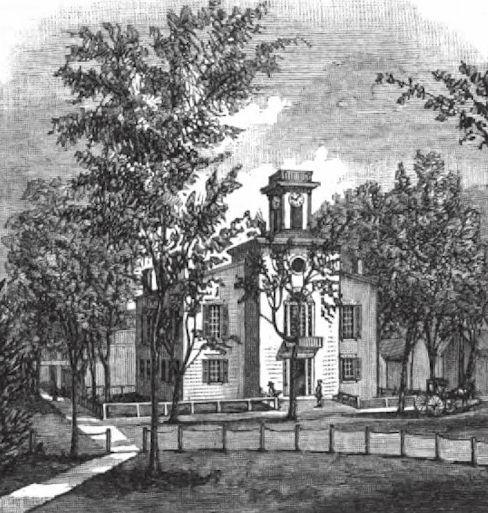
Sussex County Courthouse,
Georgetown, Del.
Footnotes:
1. Peter Alrichs took
up a tract of land at the Horekill, while ke was in command
under the Dutch, but a patent was not obtained, and, upon the
capture of the territory by the English, in 1604, all the land
in his possession, both in New Castle County and at the
Whorekill, was confiscated and later granted by Governor Richard
Nichols in 1666, to William Tom, clerk of the courts "on
Delaware." A tract at the Whorekill was granted to Turn, and his
name appears in a list of persons whose quit-rents are still
due, as follows: "Will Tom, at Grt Whorekill, 2 bushels." This
tract was on the Whorekill and on the side of Pagan's Creek. It
contained one hundred and thirty-two acres and was re-surveyed
to him July 7, 1676.
2. Samuel Jennings,
later Governor of New Jersey, in a letter October 17, 1680, to
Penn Lawrie and Lucas, assignees of Edward Bylliags, says, "In
good time we came to anchor in Delaware where one, Peter Alrichs,
came aboard and brought a handsome present to our Commander and
sent for me into the round-house, where they both were, and
Peter told me he had nothing to say relating to customs he had
no commission for it, nor did he know anybody that had.
3. From a manuscript in the British Museum the
writer (who was informed by a soldier who was in the fort at the
Hoorenkill when under the Dutch in 1662) says concerning the
creek at that place "that along the seashore it was not above
two leagues from the cape, and that near the fort, which is at
the mouth of the creek, it is about two hundred paces broad, and
navigable to about half a league upward; the pilots say
generally about six feet of water in going in, but canoes can go
two leagues higher. There were two small islands in it, the
first very small, the last about half a league in circumference,
both overgrown with fine grass, especially the latter, and all
about half a league asunder, and the latter about a league from
the channels mouth. The two islands are surrounded with muddy
ground, in which there grows the beet sort of oysters, which
ground begins near the first Island, for the mouth of the
channel has a sandy bottom, being also very deep, and therefore
there are no oysters there. Near the smaller island, and higher
up, it is broad again as at the mouth. Near the fort the channel
for a good way runs at equal distances from the sea, having the
breadth of about two hundred paces of high downy land lying
between them. Near the fort there is a glorious spring of fresh
mater. A small rill, rising in the southeast part of this
country, and falling from a rising hill, runs through this downy
land into the mouth of the Horekill, is for its goodness and
fertility named for the very best of New Netherland.''
Smith writing of this manuscript
says: "Soon after English possession it got the name of
Lewestown, by which it is mostly called. It is situate at the
mouth of Delaware Bay, and is a general resort for pilots
waiting to convey vessels up the river. Where the creek is
described as deep and sandy is now a mowing marsh. The channel
also, by the Whorekill, then used for vessels to pass, is
diminished to about a hundred yards at the mouth. The two
islands, one very small and the other half a league in
circumference, are now, the first, supposed to be ten, and the
last thirty times as large as then described, and this
alteration in about one hundred years." Smith is mistaken in the
place being called Lewestown soon after the English took
possession. It was not until after 1690 that the name was used
in official records.
4. Richard Perrott settled in Cedar Creek
Hundred, on the bay, at that time in Horekill district or
county, and the land was held by the family through three
generations.
5. Perrott's letter
caused a lengthy correspondence between Governor Lovelace and
Lord Baltimore, on the subject of the western and southern
boundary, which had been in dispute since the earliest
settlement of the country, and was not finally reconciled until
nearly a century later.
6. On the reorganization of the courts, in 1676,
by Governor Andross, they were authorized to issue warrants for
land to settlers, subject to survey to be approved by the
authorities at New York.
7. Revell's tract was
surveyed August 3, 1675. It was on "Slaahter's Creek, near to
the Whorekill."
8. Alexander Molestine
9. Penn arrived at New Castle October 27, 1682,
and the following day received the territory of Delaware from
John Moll and Ephraim Hermans. He returned to Upland the same
day and wrote to the magistrates from there. Whorekill was
divided and St. Jones County formed oat of it by Governor
Andross in 1680.
10. Whorekill had meantime been changed to
Sussex "The extent thereof shall be from the main branch of
Mispillion Creek, called the three runs northwards, and
southwards to Assawomset Inlet."
11. The suggestion of Penn in this letter to
the division of lands among ten families is in accordance with
the old English custom of dividing land among ten families,
assuming that each family with its servants was ten in number,
making one hundred, and from which fact the title "hundred" was
originally derived, and this suggestion of Penn's is doubtless
the reason why the term obtained in this State.
12. Cape Henlopen.
13. There was no naval officer in Whorekill at
this time, but on August 8, 1686, Henry Bowman was appointed.
14. This is the first mention of the term
"Hundred" in the Sussex records. The Provincial Council, April
9, 1690, instructed the magistrates and grand juries of the
several counties to divide them into hundreds. In 1690 there
were Rehobah and Broadkill Hundreds with the addition, in 1702,
of Cedar Hook Hundred, and in 1706, of Indian Creek Hundred.
15. The territory of Sussex County was not
extended southward nor westward until after 1765, and the four
hundreds, Lewes and Rehoboth, Indian River, Broadkiln and Cedar
Creek, comprised the territory of the county for at least three
quarters of a century. Among the old settlers of half a century
ago it was known as "Old Sussex." In confirmation of this term,
a deed made, bearing date November 6, 1764, of land in the
western part of Broadkiln Hundred, recites of the parties that
they were John Clowes, Jr., of Sussex County, Benjamin Mifflin,
of Philadelphia, and "John Jones, of Worcester County, alias New
Sussex." This was but a year after the first surrey line was
made, and the territory formerly Worcester County, Maryland,
this early was recognized as really belonging to Sussex County.
In 1786 an effort was made to form a new county out of Sussex
and Kent, to embrace the territory between Murderkill Creek and
Broad Kiln Creek, and the Delaware Bay and the Maryland line.
Six petitions bearing three hundred and ninety-one signatures
were presented to the Legislature, but without success, and the
movement was never revived.
Sussex County
Source: History of Delaware, 1609-1888,
Volume I, by J. Thomas Scharf, L. J. Richards & Company,
Philadelphia, 1888.
|